


Named in honour of Adelaide of Saxe-Meiningen, queen consort to King William IV, the city was founded in 1836 as the planned capital for a freely-settled British province in Australia. Colonel William Light, one of Adelaide's founding fathers, designed the city and chose its location close to the River Torrens, in the area originally inhabited by the Kaurna people. Light's design set out Adelaide in a grid layout, interspaced by wide boulevards and large public squares, and entirely surrounded by parklands. Early Adelaide was shaped by prosperity and wealth — up until the Second World War, it was Australia's third largest city. It has been noted for early examples of religious freedom, a commitment to political progressivism and civil liberties. It has been known as the "City of Churches" since the mid-19th century.

Alice Springs - Alice Springs is the third largest town in the Northern Territory, Australia. Popularly known as "the Alice" or simply "Alice", Alice Springs is situated in the geographic center of Australia. ‘The Alice’, as it is known, combines laid-back charm with all the modern conveniences, comforts and diversions you’d find in a good-sized town. The site is known as Mparntwe to its original inhabitants, the Arrernte, who have lived in the Central Australian desert in and around what is now Alice Springs for thousands of years. "Alice" in the English language was named by surveyor William Whitfield Mills after Lady Alice Todd, wife of the telegraph pioneer Sir Charles Todd.
Alice Springs has a population of 28,605, which makes up 12.2 percent of the territory's population.
 The town straddles the usually dry Todd River on the northern side of the MacDonnell Ranges. The surrounding region is known as Central Australia, or the Red Centre, an arid environment consisting of several different deserts. In Alice Springs temperatures can vary dramatically, with an average maximum temperature in summer of 35.6 °C (96.1 °F) and an average minimum temperature in winter of 5.1 °C (41.2 °F).
Alice Springs has faced many issues in recent years, largely stemming from an increase in crime and a strong racial divide that has existed for years in the town.
World War II brought significant changes to Alice Springs. Prior to the war, Alice Springs was an extremely isolated settlement of fewer than 500 people. During the war, however, the town was an extremely active staging base, known as No. 9 Australian Staging Camp, and a depot base for the long four-day trip to Darwin. The railway hub in Alice Springs was taken over by military operations and the number of soldiers posted in Alice Springs grew rapidly, as did the number of personnel passing through on their way to and from Darwin. When Darwin was threatened by Japanese forces, the sea routes—the Northern Territory capital's primary means of transportation and resupply—were cut off. The evacuation of Darwin first brought a large number of civilians including elected officials and many of the territory government's records. Alice Springs became the war-time civilian capital of the Northern Territory. When Darwin was bombed by Japanese air forces, a large number of military personnel and their heavy equipment were rapidly moved south to Alice Springs.
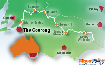
The Coorong - Located in Southern Australia, southeast of Adelaide, the
Coorong is a place of tranquility, solitude and wonderment.
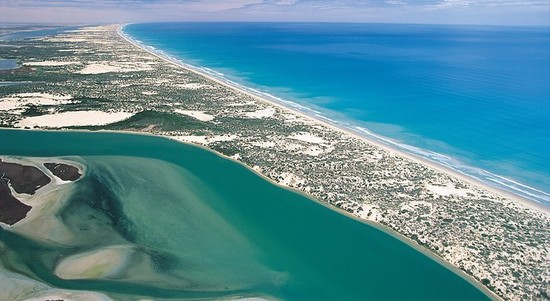 The distinctive landscape is an important breeding area for the Australian pelican and is a refuge for ducks, swans, cormorants, terns, grebes and numerous species of migratory birds.
 The Coorong, most likely derived from an Aboriginal word karangk meaning narrow neck, is one of the most breathtaking national parks in Australia. The Coorong is of Aboriginal significance and renowned for its archaeological sites.
Stretching more than 130 kilometres, Coorong National Park protects a string of saltwater lagoons which are sheltered from the Southern Ocean by the sweeping sand dunes of the Younghusband Peninsula.
The western end of the Coorong lagoon is at the Murray Mouth near Hindmarsh Island and the Sir Richard Peninsula, and it extends about 130 kilometres (81 mi) southeast. The Coorong National Park park was formed in 1966 as a sanctuary for many species of birds, animals and fish. It attracts many migratory species. It provides refuge for these animals during some of Australia's regular droughts. The 467 square kilometres (180 sq mi) also supports coastal dune systems, lagoons and coastal vegetation.
One of the unique aspects of the Coorong is the interaction of water along its length, with sea water and Murray River water meeting rainfall and groundwater. The freshwater supports the fauna (animal) of the area while the sea water is the habitat for much of the birdlife.
The waters of the Coorong are a popular venue for recreational and commercial fishers. The popular 'Coorong Mullet' and 'school mulloway' are the main species.
A wetland of international significance and important archaeological site, the Coorong is of enormous cultural significance to the Ngarrindjeri people, with ancient mounds of discarded shells revealing archaeological evidence of Aboriginal campsites over thousands of years.

The town of Hay is a historic farming town in the heart of Country New South Wales. Located on the banks of the Murrumbidgee River and surrounded by the vast grasslands of One Tree Plain, Hay has many fine heritage buildings and a diverse collection of museums.
During World War II Hay was the location of internment and prisoner of war camps, due in no small measure to its isolated location. Three high-security camps were constructed there in 1940. The first arrivals were over two thousand refugees from Nazi Germany and Austria, many of them Jewish, aged between 16 and 45. They had been interned in Britain when fears of invasion were at their peak, and were then transported to Australia aboard the HMT Dunera. They arrived at Hay on 7 September 1940 in four trains from Sydney and were interned in Camps 7 and 8 (located near the Hay showground) under the guard of the 16th Garrison Battalion of the Australian Army.
Later known as the 'Dunera Boys', the internment at Hay of this assemblage of refugees from Nazi oppression in Europe was an important milestone in Australia's cultural history. 800 of those interned at Hay eventually chose to remain in Australia. The influence of this group of men on subsequent cultural, scientific and business developments in Australia is difficult to over-state; many became an integral and celebrated part of the nation’s cultural and intellectual life. The 'Dunera Boys' are still fondly remembered in Hay. Every year the town holds a 'Dunera Day' in which many surviving internees return to the site of their former imprisonment.
 Uluru - Sometimes known as Ayers Rock, Uluru is a large sandstone rock formation in the southern part of the Northern Territory in central Australia.
Uluru rises 348 metres above the plain, more than 860 metres above sea level. That's higher than the Eiffel Tower in Paris or the Chrysler Building in New York.
If you walk right around the base of Uluru, you'll find it has a circumference of 9.4 kilometers, or about 5.8 miles.
In summer it can get really hot. Temperatures can reach up to 47 degrees Celsius in summer, that's over 116 degrees Fahrenheit. But you might be surprised to learn that the park still gets around 307 millimetres of rainfall a year and temperatures can drop to minus seven degrees Celsius, 19 degrees Fahrenheit, on winter nights.

In 1950 Ayers Rock, today known as Uluru, was declared a national park. In 1958 both Ayers Rock and Mt Olga (Kata Tjuta) were excised from an Aboriginal reserve to form the Ayers Rock/Mt Olga National Park. It took more than 35 years campaigning for Ananou, the native Aboriginal people, to be recognized as the park's traditional owners and given the deeds back to their land.
Ananou now own all of Uluru and Kata Tjuta and lease it back to Parks Australia to be jointly managed as a national park. This arrangement first came into place in October 1985, in an historic moment known today as handback.
No comments:
Post a Comment